


ST ALBANS Voting District, Hancock County, Illinois
About
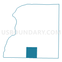
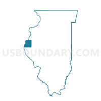
Outline

Summary
| Unique Area Identifier | 571114 |
| Name | ST ALBANS Voting District |
| County | Hancock County |
| State | Illinois |
| Area (square miles) | 36.13 |
| Land Area (square miles) | 35.99 |
| Water Area (square miles) | 0.13 |
| % of Land Area | 99.64 |
| % of Water Area | 0.36 |
| Latitude of the Internal Point | 40.23930660 |
| Longtitude of the Internal Point | -91.21655700 |
Maps

Graphs
Select a template below for downloading or customizing gragh for ST ALBANS Voting District, Hancock County, Illinois


Neighbors
Neighoring Voting District (by Name) Neighboring Voting District on the Map
- BEAR CREEK Voting District, Hancock County, IL
- CHILI Voting District, Hancock County, IL
- HARMONY Voting District, Hancock County, IL
- HOUSTON 1 Voting District, Adams County, IL
- KEENE 1 Voting District, Adams County, IL
- LIMA 1 Voting District, Adams County, IL
- WALKER Voting District, Hancock County, IL
- WYTHE Voting District, Hancock County, IL
Top 10 Neighboring County Subdivision (by Population) Neighboring County Subdivision on the Map
- Chili township, Hancock County, IL (657)
- Keene township, Adams County, IL (604)
- Lima township, Adams County, IL (534)
- St. Albans township, Hancock County, IL (377)
- Bear Creek township, Hancock County, IL (345)
- Walker township, Hancock County, IL (333)
- Harmony township, Hancock County, IL (326)
- Wythe township, Hancock County, IL (248)
- Houston township, Adams County, IL (221)
Top 10 Neighboring Place (by Population) Neighboring Place on the Map
Top 10 Neighboring Elementary School District (by Population) Neighboring Elementary School District on the Map
Top 10 Neighboring Secondary School District (by Population) Neighboring Secondary School District on the Map
Top 10 Neighboring Unified School District (by Population) Neighboring Unified School District on the Map
- Community Unit School District 4, IL (4,314)
- Southeastern Community Unit School District 337, IL (3,209)
- Warsaw Community Unit School District 316, IL (2,653)
Top 10 Neighboring State Legislative District Lower Chamber (by Population) Neighboring State Legislative District Lower Chamber on the Map
Top 10 Neighboring State Legislative District Upper Chamber (by Population) Neighboring State Legislative District Upper Chamber on the Map
Top 10 Neighboring 111th Congressional District (by Population) Neighboring 111th Congressional District on the Map
Top 10 Neighboring Census Tract (by Population) Neighboring Census Tract on the Map
- Census Tract 101, Adams County, IL (4,451)
- Census Tract 9543, Hancock County, IL (3,721)
- Census Tract 102, Adams County, IL (3,720)
- Census Tract 9542, Hancock County, IL (2,460)